The Norfolk Photography Project, sometimes just called The Norfolk Project, commenced in 2001 and gradually developed over a number of years. The first images of the project, however, date back to 1998. Originally I’d planned for the documentary and landscape project to last around five years. I then began to realise that the project could run over a much greater time frame and be far more detailed than I’d first envisaged.
Why Norfolk?
The first question probably is: Why Norfolk? You don’t live there. Well, that is very much part of the reason for choosing the county. It’s an incredibly diverse part of the UK with a large coastline, flat arable land and the waterways of the Norfolk Broads. It also has a fascinating history including the county’s role in becoming a huge airbase during World War Two. Each visit to the county covered a broad range of subject matter.
The long-term aspect of this project is important. I’d never had any photography project last anywhere near as long or as big as this one. The aim was to develop something that I could return to again and again. Over the years it has grown into a large collection of images covering a broad range of subject matter.
Norfolk during World War II
During World War Two, Norfolk took on an especially important role in the war for a couple of reasons. First of all the county was heavily fortified against German invasion along with its coast and inland areas. Norfolk was the nearest part of England to Germany and was considered the most likely place for a German invasion attempt. Using a sophisticated network of gun emplacements and machine gun pillboxes, the Norfolk coast was prepared to repel a Nazi invasion.
Later in the war, Norfolk became one huge aircraft carrier packed with no less than 37 airfields in operation. The European air campaign by the United States Army Air Force (USAAF) and Royal Air Force (RAF) was based largely on these airfields. You don’t have to go far to see the visible scars of Norfolk’s important wartime role. Some of the airfields remained in military use during the cold war. A few remain active in the 21st century.
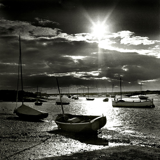
These days the county offers a great blend of coastal and rural experiences. Everyone from the bird watcher to the water sports enthusiast can find somewhere to enjoy their free time. Tourism is a huge part of the economy which brings both advantages and disadvantages. Indeed a detailed photography project could just be shot about the Norfolk Broads alone. Documenting the vast network of artificial waterways, the boats and the people who navigate, holiday and work on them. No real plan was made each year of what to photograph. The images just came to the camera and ranged from landscape to street photography.
A Long-Term Project
The first hints of the project began to emerge slowly in late 1998. It did, however, take some time for the photography to gel together as a project. It wasn’t until 2001 that the idea of doing a planned project really started to take shape. There was never any clear structured plan for the photography at the start, although the project did start with a loose framework of a five-year lifespan and 35mm photography only.
That rigid criterion was quickly altered to include medium format (6×6 especially) and digital formats. Possible formats for inclusion in the project at a later date include large-format photography, audio and video. Photography moved with technology. The project has developed gradually over the years with certain aspects being rejected or included; that’s the great thing about long-term projects. You have the time to think them out more. A big influence was the 1993 photography book series Photographer’s Britain where a photographer photographed a particular part of the UK special to them. The photographer John Tordai chose Northumberland and produced an excellent book about the county using a documentary landscape style. That book became a major influence on the Norfolk project.
Not just Landscapes
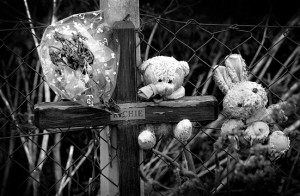
Throughout the project, photography has always remained in a documentary style. Like the Tordai book, I wanted the imagery to cover a broader spectrum of topics as possible. I wanted to document aspects of Norfolk away from the normal, more obvious seaside holiday destination. A set of images taken early in the project covered the darker side of seaside life focusing on the flowers and memorials left on the cliff top at Hunstanton. What amazed me most about these small tributes to suicide victims was the lack of engagement from the passing tourists. Only a few seem to notice or wanted to acknowledge, that a place of sun, sea and fun for one family, had become a place of grief and loss for another. Somehow it felt out of place, to have these sad reminders of lost life in the same location.
A number of the memorials were visited semi-regularly with some even displaying pretty much permanent crosses or markers. The issue appears to have been kept low-key. However, on one noticeable section, the cliff-top fence was literally covered in Samaritan posters giving a number to ring if someone needed help. Obviously, the suicide rate was a huge issue that needed to be addressed. Again people walked by these posters without seeming to notice them. It was as if anything sad was tuned out. Yet the sad events that took place on those cliffs had become part of the holiday experience of walking along the cliff top. Sometimes you can’t help but notice!
A Diverse County
We tend to forget when we visit resorts that they are working environments where people go about their lives and are not just pretty holiday destinations. The issues in Norfolk are varied and differ little from any of the other rural counties in England. Some issues do appear in more subtle ways though, whether it be an expensive car or signs for the Samaritans.
The distorting power of money does have a big effect on the community, the economy and the county. In Norfolk, you can see it clearly. If you start house hunting at Burnham Market and work your way east along the coast, you’ll soon see a financial gradient effect where second home buyers, largely from the south of England, have driven the housing prices up in selected areas like Burnham Market.
The results of excessive second home ownership can be semi-deserted villages during the winter months as local people are driven out due to housing issues, rising living costs and lack of job opportunities. The popularity of the county has caused social shifts to occur which then lead to other social issues that become increasingly harder to solve. Most rural areas are affected by this to some degree. Norfolk, however, does seem to be more susceptible due to its close proximity to London. Similar issues can also be seen in counties like Cornwall and Devon.
Monuments of War
There is still lots to photograph in Norfolk. One area I’d like to concentrate on in future visits is the relics of war that have become part of the Norfolk landscape. Pillboxes, gun emplacements and airfields act as reminders that the county was once an intensely militarised area. In some places, these memorials of the past have become tourist attractions, telling their story to generations of people passionate about the past. Others remain forgotten, quiet and alone in a secluded section of woods or fields. Gradually fading away as the years go by.
Former airfields like the one at Thorpe Abbotts have taken on a role informing tourists of the wartime role of the county. Other airfields remain in use whereas other sites remain forgotten and empty or have simply returned to agricultural use. Defensive fortifications like the roadside pillboxes seen inland in a number of villages remain as reminders of the intricate World War Two defence network. It was designed to repel any potential Nazi invasion. Elsewhere the defences are starting to come under attack from the sea as the coast erodes. Over the years a number of the WW2 coastal defences have already fallen from the top of the cliff and ended up in the sea. The pillbox photograph taken in Cromer shows how another war is still underway against the sea. A war that is being lost.
The Norfolk Photography Project Status
2011 marked the tenth anniversary of the photography project, and I decided to pause the image-taking, go through what I had, and put together the first part of the project as a photography book. I’ve shot so much material over the years. Colour film, black and white film, digital, 6×6, 6×4.5 and 35mm. That collection of photography is going to take some time to put it all together into an organised collection of images. Far longer than I originally intended if I’m honest.
A large degree of the material has never been scanned or viewed on screen before. The job of putting the book together has not been an easy one and work is still underway. It does seem the best way of finishing this first phase of the project. It’s interesting looking back on the photography and seeing the various influences come through in the work. Much of the landscape work has drawn influence from the John Tordai book. Other areas of the project, in particular, the Norwich photographs, seem to take their influence from other photographers I admire like John Davies and even Sebastião Salgado. The work will be collected together into a landscape format book to be released at some point in future.
Taking a Break
The Norfolk Photography Project isn’t over, just on a hiatus. There are so many subject ideas, and probably only a few will ever see the light of day, but there’s plenty of time to develop these ideas further. The project that started with a five-year lifespan now has no cut-off point. No end date. No finishing point. With the project currently on hold, it’s time to take stock of the work produced and plan ahead for expanding the project at a later date. New formats have been added in the past and this will continue. Audio and video will be some of the formats included in the next phase of the project. There have been side offshoots from the Norfolk project too, the biggest being the book ‘Sea, Sky, Sand and Street’.
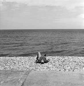
Currently, with the project on hold, the focus has shifted to creating a book from the vast collection of project images. It is now just a matter of working out the best way to use photography within a book format. A number of new images were taken in September 2016 during a week-long visit to the county with my mother. She was terminally ill with cancer at the time and the trip was a final holiday with her. Those images can be found at the end of the gallery starting with the couple on the windswept beach near Burnham Overy Staithe. The images bring a rather bitter closure to the first stages of the project. I’m hoping my next visit will be under much happier circumstances.
The gallery for this project is being updated as the Norfolk photography is collated and edited.
Favourite Photograph
It’s tough choosing a favourite from this photo project, but I’d have to say that the black and white image taken at the top of the old USAAF control tower at Thorpe Abbotts is among my top pictures. It really captured the serene atmosphere of the old airfield. The control tower has been renovated and now holds a wonderful museum dedicated to the men of the 100th Bomb Group who flew from that field. Visiting the atmospheric museum, it wasn’t hard to imagine the B-17s coming into land after another tough mission over wartime Europe. It reminded me of the haunting opening sequence to the 1949 film ‘Twelve O’Clock High‘ where a former USAAF officer returns to visit his old airfield.
Photography Prints
A RANGE OF FRAMED AND CANVAS ART PRINTS, FEATURING PHOTOGRAPHY FROM THE NORFOLK PHOTOGRAPHY PROJECT, CAN BE FOUND HERE
Photography Book
A PHOTOGRAPHY BOOK IS IN DEVELOPMENT.
